


El Fornet - Salau (Open Map)

ARVIEU
User
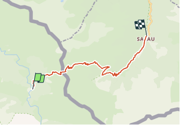

Length
12.6 km

Max alt
2091 m

Uphill gradient
685 m
Km-Effort
24 km

Min alt
855 m

Downhill gradient
1235 m
Boucle
No
Creation date :
2021-12-15 14:32:00.352
Updated on :
2021-12-15 14:32:43.393
5h30
Difficulty : Difficult

FREE GPS app for hiking
 SityTrail
IGN / Geographical institutes
SityTrail Plus
The world is yours!
About
Trail Walking of 12.6 km to be discovered at Catalonia, Lleida, Alt Àneu. This trail is proposed by ARVIEU.
Positioning
Country:
Spain
Region :
Catalonia
Department/Province :
Lleida
Municipality :
Alt Àneu
Location:
Unknown
Start:(Dec)
Start:(UTM)
345334 ; 4732685 (31T) N.
Comments